


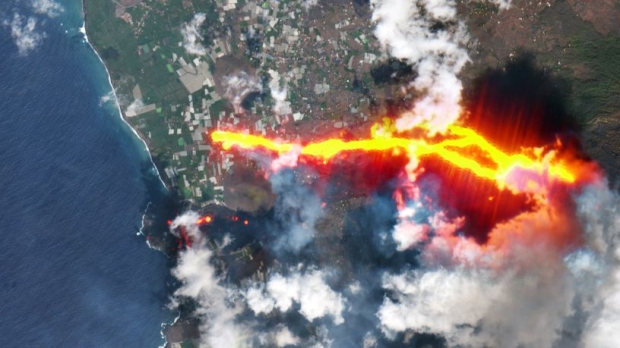
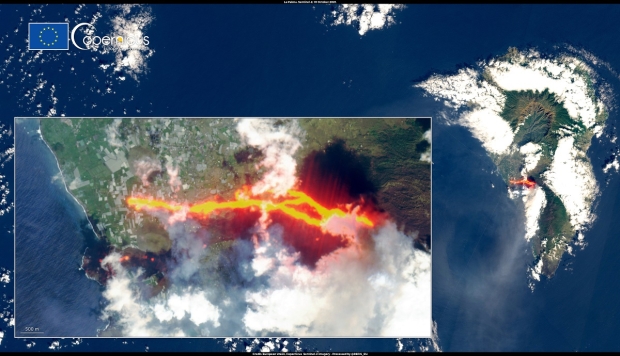
A satellite flying overhead of an erupting volcano has captured stunning images of the rivers of lava spewing from the volcano's crater.
Credit: European Union, Copernicus Sentinel-X imagery
The volcano that is erupting is on the Spain's La Palma island which first began erupting on September 19. Since then, rivers of lava have been spewing out of the volcano causing residents in the local area to evacuate. The eruption has marked the first time in 50 years this volcano has erupted, and over the weekend reports surfaced of 3.8 earthquakes in the area - indicating that the volcanic eruption is far from over.
The European Earth-observing satellite Sentinel-2 managed to capture stunning images of the La Palma eruption on Sunday that show new lava streams being created after a part of its conical crater collapsed. The collapsed crater has caused the lava up to 2,264 degrees Fahrenheit to run in new directions downhill towards the coast. So far, the lava is moving at 1,640 feet to 2,300 feet per hour. Additionally, the rivers of hot lava have destroyed more than 1,186 buildings in the area and has covered nearly two square miles of land.
For more information on this story, check out the links below.
Other Volcano News
Read more: Crazy image from space shows bulls-eye clouds above erupting Volcano
Read more: Massive volcano emerged from largest underwater eruption ever recorded
Read more: Volcano eruption captured from space, lava rivers flow into ocean
 ASUS intros ProArt PA32KCX: world's first 8K HDR Mini-LED professional monitor
 Oblivion remake rumored for a 'sooner than June' release date
 Microsoft delays the Xbox handheld to respond to the big threat from Valve
 Playing Battlefield 2042 will unlock exclusive Battlefield 6 rewards
 Giveaway: Win an ASRock B850 Riptide WiFi and Phantom Gaming PG-850G PSU
 China's CXMT is on track to nearly match Micron's DRAM production capacity by the end of 2026
 NVIDIA's RTX 50 Super GPUs have reached board partners, but launch is on hold over 3GB GDDR7 pricing
 Amazon's God of War series is recasting Kratos after Ryan Hurst suffered an on-set injury
 Physical games don't matter to GameStop, CEO says
 GameStop CEO Ryan Cohen wants to buy eBay and build out an in-game digital marketplace
 KB5101650 Windows 11 update is causing some Dell PCs to shut down unexpectedly
 Bethesda on Elder Scrolls VI, Fallout 5 Xbox exclusivity: 'It's too early to comment'
 Assassin's Creed Black Flag Resynced makes in one day what Shadows took four days to earn
 Bethesda gives news on Elder Scrolls 6, confirms 4 Fallout projects, new Starfield content
 SteelSeries Arctis Nova 7 Wireless Gen 2 Headset Review - New and Improved, But Is It Enough?
 AMD Ryzen 7 7700X3D Review - Days of Future Past
 Samsung 990 2TB SSD Review - Ninth Gen QLC at PCIe Gen4 Speeds
 ASUS ExpertBook Ultra (Panther Lake) 14" Business Laptop Review
 ASUS ROG Raikiri II Xbox Wireless Controller Review - Ready to Take Control
 MOZA FMP18 Panel Bundle Review: authentic F/A-18 Hornet cockpit controls for flight sims
 Micron 6600 ION 245.76TB Enterprise SSD Review - Best in Class Programming Speeds
 MOZA MA3F EFCM Flight Control Module Review: authentic Airbus A320 autopilot panel for simulators
 Turtle Beach Stealth Pro II Wireless Gaming Headset Review - Premium Sound, Fantastic Features
 MOZA MGX1000 Instrument Panel Review: a realistic Garmin G1000 replica for immersive flight sims
 Hisense U6SF 65-inch MiniLED TV: High Performance Meets Leisurely Convenience
 I stopped digging through Windows menus after I set up this one folder
 Don't sell your Windows laptop until you do these things
 6 PC cleaning mistakes to avoid for safer hardware maintenance
 Phison and Intel Take Aim at Local AI's Memory Wall with aiDAPTIV
 How to Remap Keyboard Keys in Windows using Microsoft PowerToys
 7 tips to organize your Windows files for faster, easier access
 Intel Arc G3 Extreme first impressions with MSI's Claw 8 EX AI+ - Incredible power for an extreme price
 How to fix Wi-Fi Adapter Not Working on Windows laptops: troubleshooting tips
 Hisense U7SG 4K TV: Modern Entertainment for the New Age