


The International Space Station (ISS) provides Earth with a unique birds-eye view of the planet from its vantage point of 250 miles above Earth's surface.

This vantage point comes in handy for tracking weather patterns, natural disasters, and other events taking place on the planet's surface. On August 12, the ISS flew over Hawaii and pointed its cameras at the Hawaiian island Maui, which is currently being engulfed in wildfires.
The floating laboratory was able to capture images of the smoke caused by the wildfires, illustrating the sheer size and impact they have had on the island and its residents.
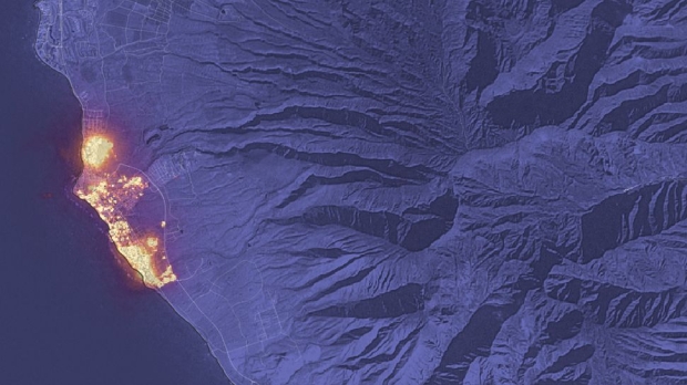
The above image was captured when the ISS was 259 miles above the Pacific Ocean, and the ISS isn't the only spaceborne device that's capturing the tragedy as NASA's Landsat 8 satellite and Europe's Sentinel-2 Earth-observing spacecraft both flew over Hawaii on August 8.

The images captured from the two aforementioned satellites showcased the horrific devastation of the wildfires, which Space.com reports is now the deadliest in the state's history, with more than 100 people confirmed dead.
- Read more: Scientists extract Pink Floyd song from a human brain and you can listen to it
- Read more: Harvard professor says godlike aliens could be creating baby universes in laboratories
- Read more: SpaceX liquidates its $373 million Bitcoin position amid chronic crypto market crash
- Read more: AI has produced more images in 1 year than cameras have over 150 years
- Read more: Jack Dorsey hangs up his Instagram boots, 'don't know why it took me so long'

 ISS cameras spot huge mysterious writing etched onto the surface of Earth
 NASA astronaut shares real-life video of Earth looking like the end of Interstellar
 NASA footage shows enchanting dance of auroras over a country from space
 SpaceX helps the ISS from tumbling back to Earth with a quick 12 minute boost
 NASA shares video of an astronaut biting down on a rare space delicacy
 Giveaway: Win an ASRock B850 Riptide WiFi and Phantom Gaming PG-850G PSU
 China's CXMT is on track to nearly match Micron's DRAM production capacity by the end of 2026
 NVIDIA's RTX 50 Super GPUs have reached board partners, but launch is on hold over 3GB GDDR7 pricing
 Amazon's God of War series is recasting Kratos after Ryan Hurst suffered an on-set injury
 Physical games don't matter to GameStop, CEO says
 GameStop CEO Ryan Cohen wants to buy eBay and build out an in-game digital marketplace
 KB5101650 Windows 11 update is causing some Dell PCs to shut down unexpectedly
 Bethesda on Elder Scrolls VI, Fallout 5 Xbox exclusivity: 'It's too early to comment'
 Assassin's Creed Black Flag Resynced makes in one day what Shadows took four days to earn
 Bethesda gives news on Elder Scrolls 6, confirms 4 Fallout projects, new Starfield content
 SteelSeries Arctis Nova 7 Wireless Gen 2 Headset Review - New and Improved, But Is It Enough?
 AMD Ryzen 7 7700X3D Review - Days of Future Past
 Samsung 990 2TB SSD Review - Ninth Gen QLC at PCIe Gen4 Speeds
 ASUS ExpertBook Ultra (Panther Lake) 14" Business Laptop Review
 ASUS ROG Raikiri II Xbox Wireless Controller Review - Ready to Take Control
 MOZA FMP18 Panel Bundle Review: authentic F/A-18 Hornet cockpit controls for flight sims
 Micron 6600 ION 245.76TB Enterprise SSD Review - Best in Class Programming Speeds
 MOZA MA3F EFCM Flight Control Module Review: authentic Airbus A320 autopilot panel for simulators
 Turtle Beach Stealth Pro II Wireless Gaming Headset Review - Premium Sound, Fantastic Features
 MOZA MGX1000 Instrument Panel Review: a realistic Garmin G1000 replica for immersive flight sims
 Hisense U6SF 65-inch MiniLED TV: High Performance Meets Leisurely Convenience
 I stopped digging through Windows menus after I set up this one folder
 Don't sell your Windows laptop until you do these things
 6 PC cleaning mistakes to avoid for safer hardware maintenance
 Phison and Intel Take Aim at Local AI's Memory Wall with aiDAPTIV
 How to Remap Keyboard Keys in Windows using Microsoft PowerToys
 7 tips to organize your Windows files for faster, easier access
 Intel Arc G3 Extreme first impressions with MSI's Claw 8 EX AI+ - Incredible power for an extreme price
 How to fix Wi-Fi Adapter Not Working on Windows laptops: troubleshooting tips
 Hisense U7SG 4K TV: Modern Entertainment for the New Age