


A newly released satellite image has revealed the devastated region in Turkey that was only recently hit with a powerful 7.8 magnitude earthquake.
According to reports on February 6, a series of violent earthquakes struck southern and central Turkey, along with western Syria. The first was the 7.8 magnitude earthquake that hit Turkey and Syria, causing hundreds of buildings to collapse and the death of what is estimated to be 11,200 people. Teams are still on the ground, attempting to find any survivors underneath the piles of rubble. The second earthquake came only hours after the first and measured 7.5 in magnitude, shaking both Turkey and Syria.
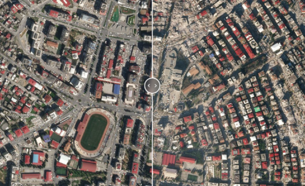
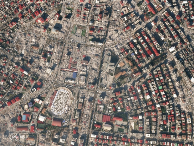
The above image was published on Twitter by Planet, where the company says one of its satellites captured a birds-eye-view of the disaster-stricken city Kahramanmaras, a city in the Mediterranean Region of Turkey. At the moment, there are few satellites images of the disaster, but companies such as Planet, Maxar, NASA, the National Oceanic and Atmospheric Administration (NOAA), and the European Space Agency are working on capturing valuable satellite images of the region that will then be given to officials assisting the people of affected regions.
Data such as this will allow on-ground officials to know the locations of the most damaged areas and apply resources to those areas appropriately, thus saving lives. However, NASA, the European Space Agency, and NOAA are yet to publish any satellite images of the region, as reports state it takes several days for the images to be gathered and organized.
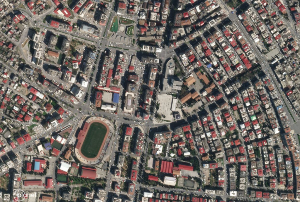
Above is an image of the city of Kahramanmaras snapped by a Planet satellite on April 3, 2021. As you can see, the city features hundreds of buildings. The image below was taken on February 9, 2023, and shows just how hard the city was hit by the two earthquakes. Notably, Kahramanmaras resides in between both of the epicenters of the earthquakes. As you can see from the below image, the earthquakes have wiped out a large chunk of the previously standing building in the above image, with the rubble even being visible from space.
In other news, NASA's Curiosity rover, which has been exploring the surface of Mars, has come across a metallic object that crashed into the surface of the red planet. NASA's rover snapped images of the object and realized it was not the first time it had encountered an object such as this. If you are interested in reading more about that story, check out the below link.

 Earthquakes might be to blame for NVIDIA GeForce RTX 50-series shortages
 Opinion: Game Pass tier with first-party games won't fix the subscription's biggest problem
 Giveaway: Win an ASRock B850 Riptide WiFi and Phantom Gaming PG-850G PSU
 China's CXMT is on track to nearly match Micron's DRAM production capacity by the end of 2026
 NVIDIA's RTX 50 Super GPUs have reached board partners, but launch is on hold over 3GB GDDR7 pricing
 Amazon's God of War series is recasting Kratos after Ryan Hurst suffered an on-set injury
 Physical games don't matter to GameStop, CEO says
 GameStop CEO Ryan Cohen wants to buy eBay and build out an in-game digital marketplace
 KB5101650 Windows 11 update is causing some Dell PCs to shut down unexpectedly
 Bethesda on Elder Scrolls VI, Fallout 5 Xbox exclusivity: 'It's too early to comment'
 Assassin's Creed Black Flag Resynced makes in one day what Shadows took four days to earn
 Bethesda gives news on Elder Scrolls 6, confirms 4 Fallout projects, new Starfield content
 SteelSeries Arctis Nova 7 Wireless Gen 2 Headset Review - New and Improved, But Is It Enough?
 AMD Ryzen 7 7700X3D Review - Days of Future Past
 Samsung 990 2TB SSD Review - Ninth Gen QLC at PCIe Gen4 Speeds
 ASUS ExpertBook Ultra (Panther Lake) 14" Business Laptop Review
 ASUS ROG Raikiri II Xbox Wireless Controller Review - Ready to Take Control
 MOZA FMP18 Panel Bundle Review: authentic F/A-18 Hornet cockpit controls for flight sims
 Micron 6600 ION 245.76TB Enterprise SSD Review - Best in Class Programming Speeds
 MOZA MA3F EFCM Flight Control Module Review: authentic Airbus A320 autopilot panel for simulators
 Turtle Beach Stealth Pro II Wireless Gaming Headset Review - Premium Sound, Fantastic Features
 MOZA MGX1000 Instrument Panel Review: a realistic Garmin G1000 replica for immersive flight sims
 Hisense U6SF 65-inch MiniLED TV: High Performance Meets Leisurely Convenience
 I stopped digging through Windows menus after I set up this one folder
 Don't sell your Windows laptop until you do these things
 6 PC cleaning mistakes to avoid for safer hardware maintenance
 Phison and Intel Take Aim at Local AI's Memory Wall with aiDAPTIV
 How to Remap Keyboard Keys in Windows using Microsoft PowerToys
 7 tips to organize your Windows files for faster, easier access
 Intel Arc G3 Extreme first impressions with MSI's Claw 8 EX AI+ - Incredible power for an extreme price
 How to fix Wi-Fi Adapter Not Working on Windows laptops: troubleshooting tips
 Hisense U7SG 4K TV: Modern Entertainment for the New Age