


A killer tornado that ripped through several US states has been photographed by NASA satellites, drawing a stark image of the destruction it caused.
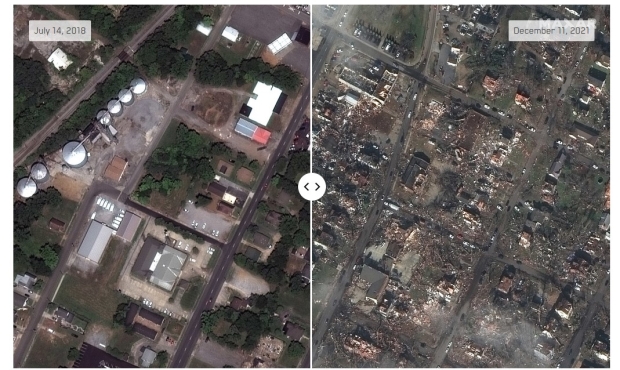
On December 10, Arkansas, Illinois, Kentucky, Mississippi, Missouri, and Tennessee felt the intense power of a tornado that has now killed at least 70 people. The storm cell was tracked across the US, and reports indicate that it traveled for more than 250 miles, leaving behind a wake of destruction that has now been captured from space.
According to the National Weather Service (NWS), more than 100 warnings were issued the night of the tornado, a record number for any day in December. The image captured by NASA's Aqua satellite using the Moderate Resolution Imaging Spectroradiometer (MODIS) showcases the tornado damage in Mayfield, Kentucky. Additionally, the NWS reported wind speed during the tornado was between 158 - 206 miles per hour.

If you are interested in reading more about this story, check out this link here.

 Scientists squint their eyes concerningly at Earth-sized shadows appearing on Jupiter's surface
 Hurricane Helene ruins North Carolina town that mines 70-100% of quartz used in semiconductors
 Starfield comes to PS5 on April 7 for $50, new story DLC Terran Armada launches same day
 Collective Shout Interview: 'Steam's Sexual Violence Game Defenders Are Abusers in Real Life'
 Giveaway: Win an ASRock B850 Riptide WiFi and Phantom Gaming PG-850G PSU
 China's CXMT is on track to nearly match Micron's DRAM production capacity by the end of 2026
 NVIDIA's RTX 50 Super GPUs have reached board partners, but launch is on hold over 3GB GDDR7 pricing
 Amazon's God of War series is recasting Kratos after Ryan Hurst suffered an on-set injury
 Physical games don't matter to GameStop, CEO says
 GameStop CEO Ryan Cohen wants to buy eBay and build out an in-game digital marketplace
 KB5101650 Windows 11 update is causing some Dell PCs to shut down unexpectedly
 Bethesda on Elder Scrolls VI, Fallout 5 Xbox exclusivity: 'It's too early to comment'
 Assassin's Creed Black Flag Resynced makes in one day what Shadows took four days to earn
 Bethesda gives news on Elder Scrolls 6, confirms 4 Fallout projects, new Starfield content
 SteelSeries Arctis Nova 7 Wireless Gen 2 Headset Review - New and Improved, But Is It Enough?
 AMD Ryzen 7 7700X3D Review - Days of Future Past
 Samsung 990 2TB SSD Review - Ninth Gen QLC at PCIe Gen4 Speeds
 ASUS ExpertBook Ultra (Panther Lake) 14" Business Laptop Review
 ASUS ROG Raikiri II Xbox Wireless Controller Review - Ready to Take Control
 MOZA FMP18 Panel Bundle Review: authentic F/A-18 Hornet cockpit controls for flight sims
 Micron 6600 ION 245.76TB Enterprise SSD Review - Best in Class Programming Speeds
 MOZA MA3F EFCM Flight Control Module Review: authentic Airbus A320 autopilot panel for simulators
 Turtle Beach Stealth Pro II Wireless Gaming Headset Review - Premium Sound, Fantastic Features
 MOZA MGX1000 Instrument Panel Review: a realistic Garmin G1000 replica for immersive flight sims
 Hisense U6SF 65-inch MiniLED TV: High Performance Meets Leisurely Convenience
 I stopped digging through Windows menus after I set up this one folder
 Don't sell your Windows laptop until you do these things
 6 PC cleaning mistakes to avoid for safer hardware maintenance
 Phison and Intel Take Aim at Local AI's Memory Wall with aiDAPTIV
 How to Remap Keyboard Keys in Windows using Microsoft PowerToys
 7 tips to organize your Windows files for faster, easier access
 Intel Arc G3 Extreme first impressions with MSI's Claw 8 EX AI+ - Incredible power for an extreme price
 How to fix Wi-Fi Adapter Not Working on Windows laptops: troubleshooting tips
 Hisense U7SG 4K TV: Modern Entertainment for the New Age