


Officials are currently tracking a "monster" cyclone that is expected to bring heavy rainfall to certain areas across the United States.
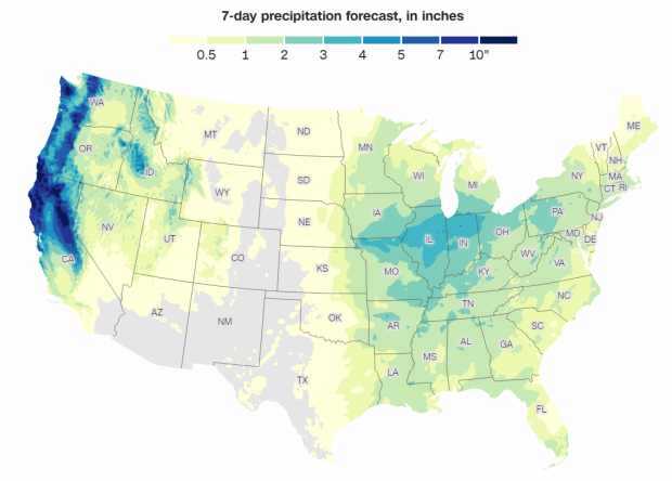
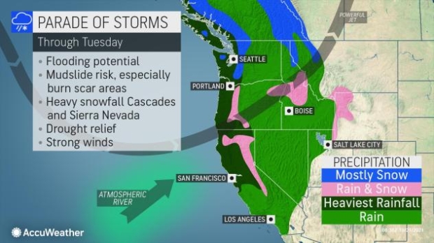
Reports indicate that this "bomb cyclone" is expected to bring heavy rainfall and snow across the West Coast over the weekend. It's expected that this series of storms could bring as much as a foot of rainfall as well as up to three feet of snow in Sierra Nevada. Additionally, the storms have been supercharged by an atmospheric river pattern, which could lead to flash flooding and the spreading of debris from regions that have been subjected to wildfires.
According to Marty Ralph, director of the Center for Western Weather and Water Extremes at UC San Diego, "An atmospheric river marked as a category 4 or a 5 is capable of producing remarkable rainfall totals over three or more days, likely to exceed 10-15% of a typical year's precipitation in some locations." As for the categorization of a "bomb cyclone", the National Ocean Service explains that the name comes from meteorologists who observe a "midlatitude cyclone rapidly intensifies, dropping at least 24 millibars [atmospheric pressure] over 24 hours." Typically, a range in millibar change is around 10 to 15 in 24 hours.
AccuWeather forecaster Paul Pastelok said, "The pattern unfolding this week to next week may be one of the biggest series of storms for the rainy season for California, but there is still potential for a couple of bigger storms over the winter."

The arrival of the storm is expected to be Thursday, October 21, to Friday. However, another storm is expected to hit on Sunday into Monday. For more information on this story, check out this link here.

 Worst storm in 100 years to hit Tampa Bay Florida pictured from space
 TSMC construction workers find another unexploded bomb from World War II at its chip factory
 Hawaii braces for 'wall of water' after sixth biggest earthquake ever recorded hits Russia
 NASA officially increases probability of most-dangerous asteroid hitting Earth
 NASA confirms discovery of Mars sample unlike any it has found before
 Need For Speed seemingly on ice as Criterion becomes a Battlefield studio
 51 Ubisoft employees who worked on the successful Assassin's Creed Black Flag Resynced have just been laid off
 AMD expands Ryzen 200 and 100 'Hawk Point' APU lineup with 11 new SKUs
 Open-Source Windows alternative ReactOS runs Half-Life 2 on a GTX 960
 NVIDIA and Sega to celebrate 30 years of partnership at a 'Guerrilla event' in Japan
 Mysterious AMD Ryzen 7 4700LE 'Zen 2' desktop CPU appears in a new prebuilt PC paired with an RTX 3050
 Apple bucks the PC market downtrend with 10.1% growth amid global supply constraints
 New iPhone generation could cost $300 more while Apple keeps similar profit margins
 Meta's next smart glasses to be secretly always watching, always listening
 AMD to introduce Zen 6-based EPYC CPUs at its Advancing AI Event beginning July 22
 Turtle Beach Stealth Pro II Wireless Gaming Headset Review - Premium Sound, Fantastic Features
 MOZA MGX1000 Instrument Panel Review: a realistic Garmin G1000 replica for immersive flight sims
 Simagic Zeus Formula Steering Wheel Review: premium build and advanced inputs for F1 racing
 GIGABYTE X870E Aero X3D Dark Wood Review - A woody goody
 The Super Mario Galaxy Movie (2026) 4K Ultra HD Blu-ray Review
 KTC H49S66 5K2K (5120x1440) 49-inch 180Hz Gaming Monitor Review
 HighPoint Rocket 1604L Gen5 x16 NVMe Software RAID AIC Review: half the price with full 59 GB/s speed
 Next Level Racing ERS3 Haptic Seat Review: immersive sim racing comfort with integrated haptics
 ASUS TUF Gaming X870-Pro WiFi7 W NEO Review - Tuffed up
 GIGABYTE GO27Q24G Gaming Monitor Review: Glossy OLED Gaming at 240Hz
 Don't sell your Windows laptop until you do these things
 6 PC cleaning mistakes to avoid for safer hardware maintenance
 Phison and Intel Take Aim at Local AI's Memory Wall with aiDAPTIV
 How to Remap Keyboard Keys in Windows using Microsoft PowerToys
 7 tips to organize your Windows files for faster, easier access
 Intel Arc G3 Extreme first impressions with MSI's Claw 8 EX AI+ - Incredible power for an extreme price
 How to fix Wi-Fi Adapter Not Working on Windows laptops: troubleshooting tips
 Hisense U7SG 4K TV: Modern Entertainment for the New Age
 6 underrated Microsoft Word features worth using to boost your productivity
 Level Up Your PC Gaming with these Fantastic ASUS Prime Day Deals on GPUs, Motherboards, and More