


NASA has released a new set of images captured by its Lucy spacecraft while it was conducting its first of three Earth gravity assists.
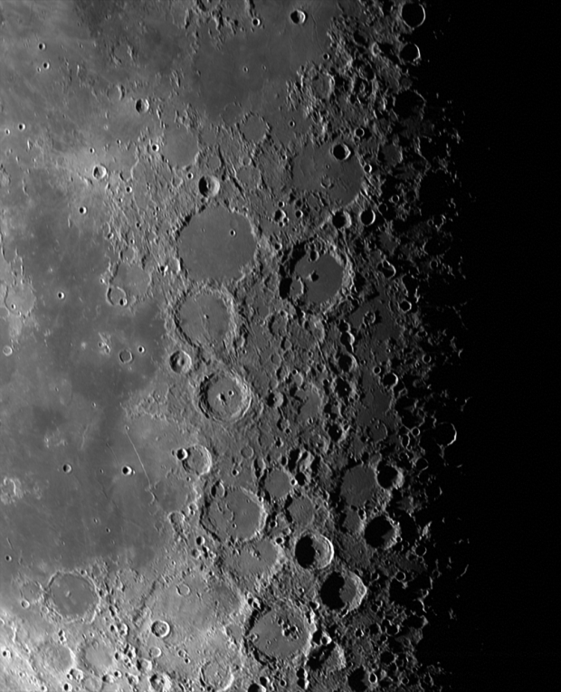
The space agency has taken to its blog to share the images captured by Lucy while it was between the Earth and the Moon, approximately 160,000 miles from the lunar surface, or about 6.5 hours after it conducted its first of three gravity assists, which is the process of using Earth's gravitational pull to gain momentum to slingshot the spacecraft further. The above image showcases a 800 mile wide patch near the center of the last quarter moon, with each pixel representing approximately 0.8 miles.
According to NASA the image was captured with the Lucy LOng Range Reconnaissance Imager (L'LORRI), and is made up of a combination of ten separate 2 millisecond exposures that have then been sharpened to bring out the most detail possible.

"This mosaic, which is made from 5 separate 1 millisecond exposures, has been sharpened. Note that the image covering the uppermost portion of the edge of the moon was taken at an earlier time, resulting in a small mismatch in the images there. Each pixel represents approximately 0.7 miles (1.2 km)," wrote NASA.
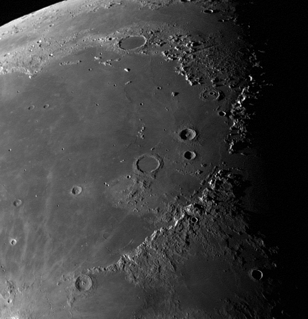
"The image shows a roughly 600 mile (1000 km) wide swath of lunar terrain, dominated by the ancient, lava-filled impact basin Mare Imbrium. The Apennine Mountains, part of the Imbrium basin rim, which were the landing site for the Apollo 15 mission in 1971, dominate the lower-right portion of the image. Lucy was approximately 140,000 miles (230,000 km) from the Moon when the image was taken," wrote NASA.

 We are now beaming back incredible Full HD footage of the Moon before landings
 NASA unveils date for when humans will explore the Moon
 NASA releases images of peanut-shaped object making close approach to Earth
 NASA's Webb photographs 'bejeweled' ring floating in deep space
 ISS astronauts witness Starship exploding and falling back to Earth
 Intel's dual-tile Nova Lake-S CPUs reportedly carry a 474W PL2 target, according to leaked Z990 power guidance
 Micron has signed agreements locking in record-high memory prices with major customers through 2030
 Analyst believes Call of Duty, EA FC, and NBA 2K will move to $80 pricing
 Valve engineers claim release cadence for future Steam Machine versions will be shorter than the Steam Deck
 AMD engineer builds a Steam Machine competitor with a 3D printer, has an RTX 5060 inside
 GTA 6 listed as 'offline play only' on console PlayStation Store, 'offline play enabled' on other Sony portals
 Scalpers are already selling the Steam Machine for over $3000 on eBay despite Valve's efforts
 Valve silently removes 4K 60 FPS marketing claim from the Steam Machine, console is now only rated for up to 4K
 GTA 6 leak suggests it'll have 'NPCs with their own routines' and social networks so you can follow in-game influencers
 Lian Li B4-mATX Review: a compact mATX SFF case with excellent airflow and premium features
 MSI MPG 322UR QD-OLED X24 Review: A Brighter, Tougher 4K 240Hz QD-OLED for $1099
 UGREEN NASync DXP4800 GT Review: powerful 4-bay NAS with AMD Ryzen and dual 10GbE ports
 Dell XPS 14 (2026) Laptop Review - Premium Quality, Impressive Performance
 Ocypus Sigma F36 BK ARGB Cooling Fan Review: high airflow and unified design in one frame
 PCCooler CPS RZ820 Display Review: a flagship-level CPU air cooler with an LCD screen
 Speed Racer (2008) 4K Ultra HD Blu-ray Review: a stunning remaster of the cult classic
 MOAIPLAY ORA PRO G1 850W ATX 3.1 PSU Review: high efficiency and 10-year warranty for $119.99
 Navman MiVue Smart True 4K Surround Dashcam Review - Seeing In All Directions At Once
 Hisense U7SG 4K TV: Modern Entertainment for the New Age
 6 underrated Microsoft Word features worth using to boost your productivity
 Level Up Your PC Gaming with these Fantastic ASUS Prime Day Deals on GPUs, Motherboards, and More
 GIGABYTE Wants to Kickstart Your New Gaming PC or Upgrade with These Limited-Time Deals
 7 Windows settings to change right after installation for better privacy, security, and performance
 I stopped Windows 11 notifications from interrupting me with Do Not Disturb, Focus, and a priority list
 I read the Windows Backup app screen carefully, and it does not back up what most people think
 Low Sound Volume on Windows 11? How to fix audio issues and restore normal volume
 8 Critical Warning Signs You Should Never Ignore in Windows 11