


In a herculean effort, Caltech's Bruce Murray Laboratory for Planetary Visualization has created what has now been deemed the most detailed 3D map of Mars ever made.
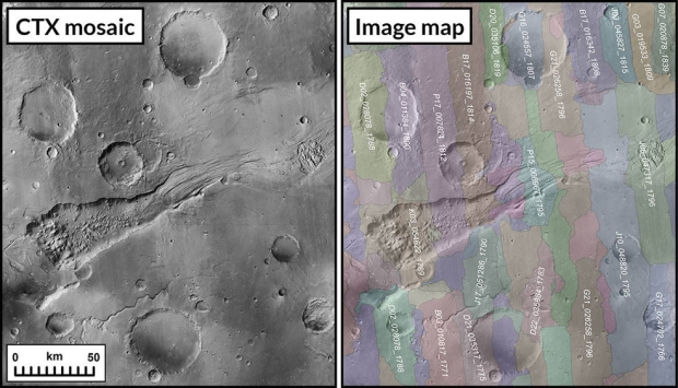
The Global CTX Mosaic of Mars map comprises more than 110,000 images snapped by NASA's Mars Reconnaissance Orbiter (MRO) black-and-white Context Camera (CTX). Each pixel represents a staggering 270 square feet or 25 square meters, and the entire mosaic image contains 5.7 trillion pixels. NASA writes on its website that if this mosaic image was printed out, it would cover the entire Rose Bowl Stadium in Pasadena, California.
The space agency explains that the new 3D map of the Red Planet took Caltech's Bruce Murray Laboratory for Planetary Visualization took six years to stitch together and tens of thousands of hours to develop. Not to mention the more than 120 peer-reviewed studies and scientific papers that were cited and implemented into its creation. The idea behind the map was to create an interactive experience that allowed anyone to explore the various different regions of Mars.
Jay Dickson, the image processing scientist who led the project and manages the Murray Lab, explained that people of all ages that are interested in learning more about Mars, its regions, impact craters, where NASA's rovers have traveled, and more are now easily able to do so.
So, how was the map made? To create a map of Mars, researchers turned to develop an algorithm that is designed to locate and match images with specific features and similarities. The algorithm was able to successfully stitch together 97,000 images, and the remaining 13,000 were manually stitched together by Dickson.
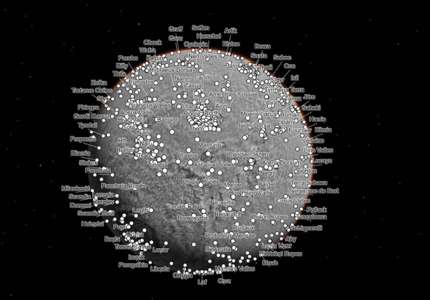
The result is a stunning map that can now be used by anyone around the world with an internet connection. Notably, users won't just consist of more than just the curious layman but also scientists looking to conduct research on certain aspects of our red neighbor. However, for the curious public, the developers of the map have provided hotkeys that transport the viewing to some of the most iconic places and objects on Mars.
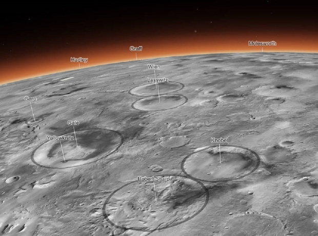
For example, users can find the specific location of NASA's Perseverance rover, which is currently exploring the Jezero Crater with its companion scout Ingenuity, or the Gale Crater, which is home to NASA's Curiosity rover, which has been slowly making its ascent of the 3-mile high Mt Sharp for the last 10 years. Additionally, locations of interest could also be Olympus Mons or NASA's deceased Opportunity rover.
To check the map out for yourself, visit this link here.

 NASA rover photographs rock unlike any other seen on Mars before
 NASA releases photographs of the holes in the tires of the latest Mars rover
 Microsoft Flight Simulator 2024 detailed: 4000x more detail, new Career mode, and SO much more
 Apple releases the most important software update of 2024 for iPhone models
 Giveaway: Win an ASRock B850 Riptide WiFi and Phantom Gaming PG-850G PSU
 China's CXMT is on track to nearly match Micron's DRAM production capacity by the end of 2026
 NVIDIA's RTX 50 Super GPUs have reached board partners, but launch is on hold over 3GB GDDR7 pricing
 Amazon's God of War series is recasting Kratos after Ryan Hurst suffered an on-set injury
 Physical games don't matter to GameStop, CEO says
 GameStop CEO Ryan Cohen wants to buy eBay and build out an in-game digital marketplace
 KB5101650 Windows 11 update is causing some Dell PCs to shut down unexpectedly
 Bethesda on Elder Scrolls VI, Fallout 5 Xbox exclusivity: 'It's too early to comment'
 Assassin's Creed Black Flag Resynced makes in one day what Shadows took four days to earn
 Bethesda gives news on Elder Scrolls 6, confirms 4 Fallout projects, new Starfield content
 SteelSeries Arctis Nova 7 Wireless Gen 2 Headset Review - New and Improved, But Is It Enough?
 AMD Ryzen 7 7700X3D Review - Days of Future Past
 Samsung 990 2TB SSD Review - Ninth Gen QLC at PCIe Gen4 Speeds
 ASUS ExpertBook Ultra (Panther Lake) 14" Business Laptop Review
 ASUS ROG Raikiri II Xbox Wireless Controller Review - Ready to Take Control
 MOZA FMP18 Panel Bundle Review: authentic F/A-18 Hornet cockpit controls for flight sims
 Micron 6600 ION 245.76TB Enterprise SSD Review - Best in Class Programming Speeds
 MOZA MA3F EFCM Flight Control Module Review: authentic Airbus A320 autopilot panel for simulators
 Turtle Beach Stealth Pro II Wireless Gaming Headset Review - Premium Sound, Fantastic Features
 MOZA MGX1000 Instrument Panel Review: a realistic Garmin G1000 replica for immersive flight sims
 Hisense U6SF 65-inch MiniLED TV: High Performance Meets Leisurely Convenience
 I stopped digging through Windows menus after I set up this one folder
 Don't sell your Windows laptop until you do these things
 6 PC cleaning mistakes to avoid for safer hardware maintenance
 Phison and Intel Take Aim at Local AI's Memory Wall with aiDAPTIV
 How to Remap Keyboard Keys in Windows using Microsoft PowerToys
 7 tips to organize your Windows files for faster, easier access
 Intel Arc G3 Extreme first impressions with MSI's Claw 8 EX AI+ - Incredible power for an extreme price
 How to fix Wi-Fi Adapter Not Working on Windows laptops: troubleshooting tips
 Hisense U7SG 4K TV: Modern Entertainment for the New Age